6/7/12

Day 3 In Transit to Phoenix Islands

This is blog entry posted from the field during the 2012 Phoenix Islands Marine Protected Area (PIPA) Expedition. The Phoenix Islands are an isolated island chain more than 1,000 miles southwest of Hawaii. They are part of the island nation of Kiribati, which partnered with the New England Aquarium and Conservation International to create PIPA in 2008. Today it is one of the world's largest marine protected areas and a UNESCO world heritage site. This voyage is part of a regular series of scientific expeditions to investigate coral health and study ecosystems and biodiversity.

This post is by Expedition Leader Sangeeta Mangubhai.

It is the third day of our travels to the Phoenix Islands and we have now covered 700 miles of open ocean. We have already changed our itinerary to suit the currents and weather conditions and are heading directly through the center of the Phoenix Islands to Kanton Atoll.


We have been blessed with calm seas and good weather all the way out and the majority of the team got their sea-legs after the first day. [Seas were much rougher during the 2009 expedition crossing.] Four of us--myself, Rob Barrel (the owner and captain of the Nai’a and who been to Phoenix Islands five times), Tuake Teema (who is our esteemed Kiribati government representative) and Craig Cook (our doctor and safety officer for this trip)--have visited the Phoenix Islands before and were part of the original pioneering expedition in 2000.


The others are new young up-and-coming scientists from WHOI, Scripps and KAUST visiting the islands for the first time. It is clear from talking to them, that they have a wealth of experience from other parts of the world and are experts in their field. Over the upcoming days, they all will be blogging and sharing a little of the research they are doing and how it will contribute to the growing body of information on the Phoenix Islands. [While in transit, the team has already started deploying data collection equipment called drifters.]


During the transit we have been sharing our local knowledge of the area of the team, reviewing our safety and biosecurity protocols, and we have started to prepare our equipment and datasheets. The team is now itchy and ready to get into the water and do their first dive in the Phoenix Islands.


In between talking to the team, I have had calm moments to sit and just reflect on the Phoenix Islands and what the place has meant to me. The Phoenix Islands changed my life and has inspired me over the last decade to work on coral conservation issues in the Pacific, East Africa and now SE Asia. The Phoenix Islands and the early expeditions we did in 2000 and 2002, are my “baseline” of what coral reefs should like in the absence of human impacts. It does not matter where in the world I work, the Phoenix Islands help me understand what a truly healthy reef looks like, if protected or managed well.


A healthy reef should been literally teaming with fish and invertebrate life against a backdrop of vibrant gardens of corals. It should be noisy and busy place with fish darting in, out and along the reefs. It should also be a place where large apex predators like sharks patrol the reefs in large numbers. As we get closer to the Phoenix Islands, I cannot wait to see how these reefs are doing. Part of me is anxious because I know how much the bleaching event in 2002/2003 affected the reefs. But the other part of me is hopeful that the fish populations are in a good condition and that there is much recovery.

-Sangeeta Mangubhai

P.S. And a special message from Rob Barrel (scuba diver) to any Rocket 21 kid reading this blog "we have arrived in Kanton and all the serious science has started so stay tuned."

6/6/12

Ocean Drifter Deployments from the NAI’A

This is blog entry posted from the field during the 2012 Phoenix Islands Marine Protected Area (PIPA) Expedition. The Phoenix Islands are an isolated island chain more than 1,000 miles southwest of Hawaii. They are part of the island nation of Kiribati, which partnered with the New England Aquarium and Conservation International to create PIPA in 2008. Today it is one of the world's largest marine protected areas and a UNESCO world heritage site. This voyage is part of a regular series of scientific expeditions to investigate coral health and study ecosystems and biodiversity.

This post is by Ben Hodges, from WHOI.

Surface currents in the world’s oceans are like highways, transporting nutrients, plankton, and other water properties, and are part of a changing, coupled climate system. In order to understand how different parts of the ocean are connected, to predict the events we might expect in the future, and to monitor the changes our planet is undergoing, we need to map these surface currents.  Drifters are oceanographic instruments designed to accurately measure surface currents by mimicking the motion of a single parcel of seawater. A drifter is composed of two parts: a surface float containing a transmitter, and a drogue, hanging below, which is a hollow tube of canvas 60 cm in diameter and a few meters long. The transmitter regularly relays the position of the drifter to scientists on land via satellite, and the drogue ensures that the drifter accurately follows a water parcel, unaffected by the wind above. A drifter can continuously report positions for approximately two years.


Ben Hodges, researcher at Woods Hole Oceanographic Institution,
describes the the science behind ocean drifters (Photo: K. Ellenbogen)

During the 2012 PIPA cruise aboard the NAI’A, several drifters will be deployed along the eastern rim of the Phoenix Islands archipelago. The prevailing westward current will likely carry these drifters near downstream islands, providing multiple realizations of the paths taken by water (and everything suspended in it) as it flows from island to island. With these current measurements, we hope to better understand how the transport of biota influences the connectivity of the islands’ ecosystems.

Ben Hodges checks drifter function prior to deployment. (Photo: K. Ellenbogen)

The PIPA cruise also provides a unique opportunity to study ocean currents over a broader area as well. Drifters aren’t the only game in town when it comes to measuring surface currents. By observing sea surface height from satellites, scientists can estimate surface currents over most of the globe (a relationship known as geostrophy), without ever leaving their cozy offices. But there’s no substitute for drifters when it comes to accurately following a parcel of near-surface water.

Deploying  a drifter from the NAI’A on 5 June 2012 during the transit from
Apia, Samoa, to the Phoenix Islands, Kirbati (Photo: K. Ellenbogen)

This is particularly true near the equator—geostrophy works better at higher latitudes. Ironically, the equatorial Pacific, one of the places where drifters can contribute the most to our knowledge of ocean currents, is also one of the hardest places to maintain a population of drifters. It is less well travelled than many other parts of the world ocean, and because of the divergence of surface currents near the equator, drifters that are deployed there usually don’t stay long. That’s where we come in. During the transit of the NAI’A from Samoa to the Phoenix Islands a drifter was deployed at each degree of latitude, seeding the southern equatorial Pacific with instruments that will help fill in a perennial gap in the existing array. While waking up at 3:00 a.m. to arm, test, and deploy a drifter in dark, pitching seas can certainly be a hassle, the detailed information about currents in such a remote part of the world more than makes up for the challenges

Map of drifter deployments planned for the 2012 NAI’A PIPA cruise. Also shown are: bathymetry (color); average currents during the month of June, calculated from satellite measurements of sea surface height (arrows);
and the planned arrival date of the NAI’A at each site.


-Ben Hodges

Expedition goals and overview - starting at Kanton!

The 2012 PIPA expedition is officially underway, and we recently got our first communication from the boat: 

"pretty calm; beginning to get organized for work beginning at Kanton".

This is good news! Calm seas and work beginning -- as we had hoped.
So, where is Kanton Island, and what is the team planning to do there?

Kanton Island

Kanton is the largest of the atolls, and has a large central lagoon, where the Nai'a will soon be anchoring in just a few hours! There is a resident group of i-Kiribati living there, and our team will be meeting with them to discuss their plans and to deliver some school supplies that were collected by Emily Mead (a local student from Weston, MA) via this very blog (the Kanton Campaign for Kids). Thanks so much to all who contributed! 

Emily collected 49.5 pounds of school supplies (I know, I weighed and packed them for transport...) and Kiribati schoolchildren will soon be receiving new math, science and reading workbooks, glue, pencils, pens, paper, crayons.... though the school year is ending here in the U.S., "back to school shopping" for Kanton kids will be today or tomorrow! Thanks, Emily!

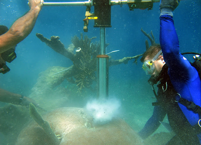
WHOI scientists remove a core sample from a massive star coral in a reef north of St. Thomas, U.S. Virgin Islands. They will do the same during this expedition to the Phoenix Islands Protected Area. (Photo: WHOI)

In addition to meeting with the i-Kiribati who live there, our team will begin their scientific objectives. The coral health and calcification team will scour the lagoon for large coral colonies, and will extract cores in order to determine the history of growth for those colonies. From the cores, they will be able to measure coral growth rates, and see changes that might indicate past bleaching or other events that would impact growth rate.

A fish otolith (ear bone) (Photo: WHOI)

Other teams will begin looking for fishes and extracting their otoliths (ear bones) for a similar purpose - reconstructing fish growth rates, age, and their trophic history (what they ate, at what life stage...) in order to determine food web links in the Phoenix Islands. [More background on otoliths here]

Dr. David Obura measures coral health in PIPA. Photo by R. Rotjan

Another team will continue the monitoring of fishes and corals that has been happening in PIPA since 2000. They will retrieve and redeploy temperature loggers, measure fish and coral abundance, diversity, size, and health, and will also capture high quality images of the shallow seafloor for subsequent analysis. 

We're hoping for some live reports amidst the busy schedules, and we'll keep you posted on the success of these important and diverse endeavors. 

Until soon... Randi.

6/4/12

Countdown...

From Sangeeta Mangubhai, Expedition Leader:

I was up at the crack of dawn – I am always like this when I am excited, and this morning my thoughts were filled with Phoenix Islands as I started counting down the final 24 hours. The rest of the team is somewhere in the sky and I headed out to buy the last minute things we needed because once we leave there will be nothing but open ocean, and with the exception of Kanton, uninhabited islands.

The Nai'a, ready to set sail for PIPA, in Apia Harbor


My mission this morning was to buy rat traps! There was a massive effort in 2009 to clear three of the PIPA atolls of rats that had been introduced and were impacting local bird populations. The Phoenix Islands, due to their isolation, have significant bird numbers, with five of the eight islands being important bird areas. The boat has been fumigated twice in Fiji and we are packing extra traps to place on the boat in case we get a few ‘naughty stowaways’ from Samoa. The Kiribati government has developed biosecurity protocols to help protect these islands, and we will be following them exactly to make sure we do not impact the marine or terrestrial life of these atolls.

We also hope to find time to visit some of the islands and see if the previous eradication programs have remained effective.

Traditional Vaka

My fellow Pacific Islander, Jay Andrew from the Palau International Coral Reef Center, who is an expert on collecting coral cores to study climate change, arrived today from Palau. As we headed to the harbor to see the ocean voyaging ‘vakas’, I was reminded and humbled by the long voyages that Pacific Islanders did across the Pacific. There were no compasses, no GPS, no radar, no radio - yet these Islanders used the seas and skies to guide them across wide expanses of open ocean.


Sangeeta, Jay, and Sue overlooking the Apia harbor
Of course, we are traveling with the Nai’a who is both outfitted with all the latest navigation tools and technology and we are bring out own inflatable hyperbaric chamber too in case someone gets decompression sickness! As we looked out to sea to watch the sun setting over the Pacific we saw the Nai’a patiently waiting for our team of scientists to arrive.

Then, to sea!

--Sangeeta

6/1/12

A celebratory start...

From Sangeeta, Expedition Leader:

I arrived yesterday in Apia, the capital of Samoa, just in time to celebrate the country’s 50th year of independence. It is the first time in 7 years that I have been back to the Central Pacific – the last time I was here was in 2005, for the third expedition to the Phoenix Islands.

First order of business upon arrival was sleep – I had to take two overnight flights from Bali, Indonesia to get here, and there was very little keeping my eyelids open when I arrived. Three hours later I emerged bleary-eyed and went straight to the Conservation International office, which is both my office and home for the next two days. I spent my day catching up with Sue Taei, who is a key supporter of the conservation and management of the Phoenix Islands Protected Area for Kiribati. She is a wealth of knowledge on what is happening in the Pacific!


CI office in Apia

So much has happened since I was here last. In the 3 years following the 2005 expedition, the Kiribati government with two key partners - Conservation International and the New England Aquarium – have moved forward and designated the Phoenix Islands as a protected area and listed it as a World Heritage Site. For an area that is 408,250 square kilometers and so remote (that it will take us 3 days to travel there by boat if the weather is kind to us), this is no small feat. I am filled with an incredible sense of pride of playing a small part in this, as I have been fortunate to participate in the first three expeditions (2000, 2002 and 2005) to document the rich coral reefs, deep sea and birdlife on these remote but pristine atolls.

At the UB40 concert with Mike Donoghue (CI head in Apia)to the L. Center = Sangeeta Mangubhai.

In between meeting and spending time with the Conservation International staff, I have been enjoying the birthday celebrations in Apia (Happy 50th!) and enjoying local food. The biggest highlight of my day was cramming into the local stadium to see a live performance by the band UB40, flown in for the birthday celebrations. I managed to get gold tickets for the area just in front of the stage with Mike Donoghue and John Watkin  - it was a phenomenal night. You could not have found more devoted fans as there were in Samoa. Swaying to “Kingston Town” and “Red Red Wine” under a moon-lit Samoan sky, I could not help but think this is a great start to the expedition!

UB40 live in Apia!!

--Sangeeta